Sky lapse in two tone
Using Sentinel-1 radar imagery to make out the shapes of our changing seaborne energy system
The European Space Agency’s Sentinel-1 satellite paints a striking picture of our changing energy system at sea.
Sentinel-1 uses synthetic-aperture radar, which can detect objects at sea and through clouds, making offshore infrastructure and shipping lanes visible as constellations of sparkling white dots.
Our economy at sea has tended to be a blind spot for satellite imagery services, with the eyes in the sky taking much more interest in what is happening on land. The world’s most well-known satellite imagery service — Google Earth — does not serve pictures of the ocean at all, which just appears as a vast mass of fuzzy blue on the platform.
Yet the ocean economy is growing faster than the global economy. Most of the international trade in fossil fuels still takes place over the sea — 60% of the world’s oil production transits by sea. It is also a key venue of the energy transition with the rapid expansion of offshore wind and with the seabed, which is also a controversial new frontier for the mining of critical minerals.
Inspired by some similar images shared by Tim Wallace in 2020, we’ve created a series of black-and-white composite renderings of some of the points of flux in the global energy system. Created in Google Earth Engine, these pictures are effectively annual timelapse images based on Sentinel-1’s radar, consisting of multiple snapshots taken by the satellite across 2023. Offshore wind farms, shipping lanes and oil and gas infrastructure glimmer like constellations of stars in a sea of black.
North Sea offshore wind
The North Sea now glitters with the world’s largest offshore wind farms. Often difficult to see clearly with non-commercial satellite imagery, Sentinel-1’s radar imaging picks out the turbines as matrices of fine white dots.
Hornsea 2, the world’s biggest offshore wind farm located off the Yorkshire coast, came online in August 2022. Alongside its sister project Hornsea 1, the cluster is made up of 339 windmills and covers an area of 335 square miles, it can provide enough electricity to power 2.4 million homes. Sentinel-1 provides a beautiful picture of its growth.
Zooming out from Hornsea, you can see many other constellations off the East Coast of England, especially around the mouth of the Humber. Robin Hawkes has built a beautiful map that lets you visualise the power generated by any of these farms at a given moment.
Some of the other clusters of light are offshore oil and gas rigs — a fundamental but declining part of the North Sea economy. According to the Financial Times, offshore wind turbines now exceed the number of oil platforms globally.
Dörtyol and shifting flows

Dörtyol is a lesser-known oil port in Turkey and the transit point at the heart of our investigation with POGO and The Washington Post into the potential laundering of Russian oil into European refineries, which supply both US and UK naval bases. Global crude oil, diesel, and gasoline flows have been reconfigured as Europe’s sanctions on Russian oil have bitten since their introduction in 2023. Some Russian hydrocarbon molecules have seemingly continued to flow into Europe but have taken more indirect routes via places like Dörtyol or India’s Jamnagar refinery.
Strait of Malacca
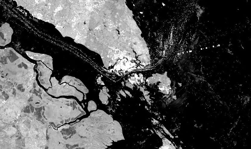
One-third of the world’s seaborne crude oil and half of globally traded goods move through the Strait of Malacca. The shipping lanes are intensely crowded, especially around Singapore, one of the world’s great trading hubs, and you can see them clearly in the radar imagery. Our research with Transport & Environment tracked the movement of tankers carrying palm oil from Indonesia to European biofuel refineries that had supposedly phased out the controversial feedstock.
Panama Canal
You can make out a snake of white light through the Panama Canal, which connects the Atlantic and Pacific and through which, until recently, 13,000 to 14,000 vessels passed a year. Our friend, Seb over at Energy Flux, has recently written about the droughts affecting the canal preventing the passage of LNG tankers and how these may ultimately lead to fragmentation of the global LNG market and lower LNG prices in Europe as the route to take American LNG to Asia becomes longer and more expensive.


